Sunday, August 31, 2014

Colvin

Days ago, we were eying the weather forecast for the Adirondacks and wallowing in self pity based on the fact that it looked like a washout for the entirety of the upcoming Labor Day weekend. However the prediction changed slightly the day before and we mobilized to get into the high peaks on Saturday.

Our choice was Colvin and Blake peaks, which we had seen the previous week from Nippletop. In fact, we would be following the same trail for most of the trip and branching off for the last few miles. We were on the trail at 6:30, earlier than we would need for the hike but undoubtedly being one of the busiest hiking days of the year we wanted to beat the crowd.

It was unusually gusty and humid for an Adirondack morning. The wind with humidity felt like an ocean breeze. We walked along the lake road as the sun rose until arriving at the Gill Brook cutoff.

Welcoming the scenery change, we started to head uphill and entered state land where we noticed quite a few tents from backpackers. Some were just rising as we headed by. The cutoff to Colvin was just ahead.

When we turned onto the Colvin trail, we followed a series of steep and flat sections. There were some scrambles but we arrived on the summit at 9:45. Sadly, the surrounding views were socked in the clouds which was disappointing after our experience on Nippletop the week before. We ate some bananas and decided to head to Blake. We would have to come to the Colvin summit on the return trip and would have a second chance at the view.


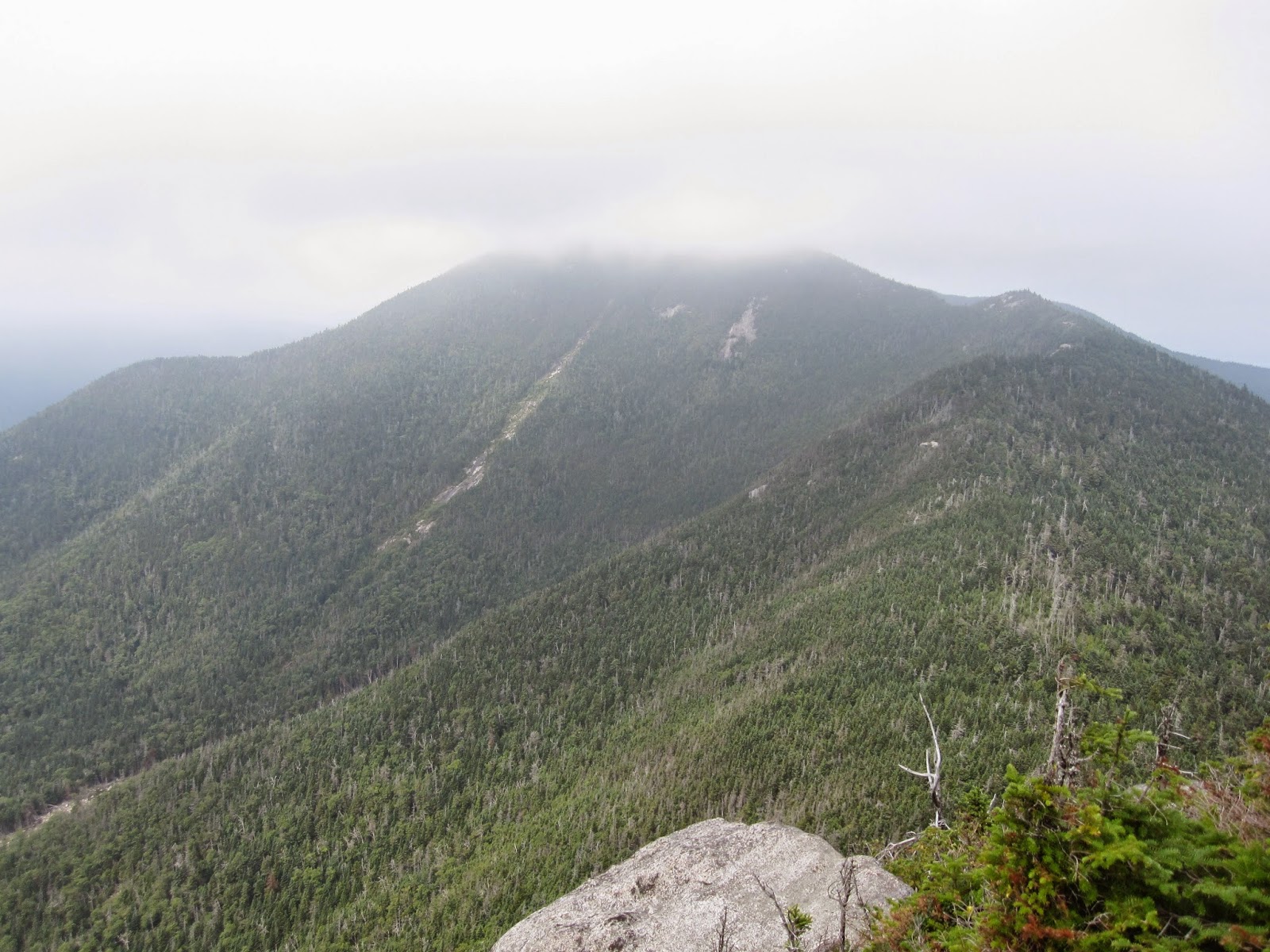
The trek to Blake was slow going with many steep rocky sections. We made our way slowly, happily finding some great views of Basin, Saddleback and Gothics along the trail. The summit itself was advertised as a 'no-view' peak in the Adirondack Mountain Club guidebook so we were happy to have such a nice trail view.


We ate our lunches on the top and chatted with other hikers before heading over the rocky scrambles again. When we arrived at the Colvin summit for our second attempt, the early morning clouds had completely blown off and we had an unobstructed view of the Great Range. We sat and stared at the massive slides on Gothics and Basin while eating the last of our food for the day before descending.


The trail down was fairly easy going except for two rocky sections which we approached at a snail pace. Arriving back at the car, we were tired and ready for some food. We headed to the Old Dock House in Essex for supper before catching the ferry home. It was a perfect day in the Adirondacks!

Sunday, August 24, 2014

Nippletop

We started our hike at 7:30 from the Ausable Club. It was a Saturday and we wanted to make sure that we had a place to park despite the fact that the hike would fit well into the daylight. Our intention was to head down towards the end of the Lake Road and take Elk Pass towards Nippletop and then descend over Dial and Bear Den Mountains.

We welcomed the trail after the long walk along the road and it climbed slightly before descending into the muddy bog of Elk Pass. After the col, the trail got quite steep - but we enjoyed the views along the trail. When we arrived at the top, the view was gone. We found ourselves huffing and staring into a cloud.


Nippletop is probably the summit on which we have spent the longest amount of time. We waited for an hour and a half and the clouds finally cleared just as we had given up. Suddenly we had a fantastic view of the Great Range and the clouds were even blowing off of Marcy in the distance. It was well worth the wait! There are not many vantage points where you can see every mountain in the Great Range:


We even got to see Dix Mountain out of the clouds looking east!


Finally, we started a long descent and after a couple miles we were eating chocolates on the summit of Dial Mountain. Even though it was about six hundred feet lower than Nippletop, the view was still stunning and the clouds had continued to clear while we hiked.


The descent that continued seemed to last forever. Bear Den did not offer any view but we did get to see this little fellow on a branch right over our heads:


Other than one clearing that had regrown with poplars (perhaps blowdown or fire area) our views for the day were over and the descent seemed to go on and on. Finally, we made it back to the Lake Road and then to the car for dinner. With the waiting on Nippletop it was a good thing that we had an early start!


Thursday, August 21, 2014

Macomb, South Dix, Grace, Hough

Our latest venture into the High Peaks brought us to the Elk Lake trailhead, a place that we had never been. We were excited to get into the Dix Range and our intention was to hike the four lower mountains in the range, excluding Dix itself.

We started at sunrise from Elk Lake and headed up the trail. There was a chance of rain forecast for the afternoon, so we wanted an early start. We turned onto the Macomb herd path after an hour and were absolutely impressed at the state of the trail. We were cruising along until we came to the slide, which was unlike any other Adirondack slide that we have ever seen. The boulders are sitting on sand and our forward progress was brought to snail pace as we scrambled up to the peak. We only had one close call where a boulder came loose and rolled right by Lisa....oops.


The views on the way up were spectacular but steadily getting more hazy. The clouds that we were hoping would wait until the afternoon were starting to roll in. We eyed Allen as one of the most prominent peaks in the distance and looked over Elk Lake as a great lake to explore by kayak or canoe.  Plus we've been tipped off that the dining hall serves a pretty tasty meal.


Macomb Peak gave us a nice view while we snacked on trail mix. The haze was beginning to roll in to the further peaks, so we made our way down.


It was an easy descent and ascent to South Dix, which had some nice views on the rocky trail but had a wooded summit. We snapped a couple shots to prove that we were there and kept marching on towards newly-named Grace Peak.


Another easy mile to Grace where we had views of the Champlain Valley and Schroon Lake areas. It was also a great view back to the Dix Range with Dix's famous Beckhorn prominent in the distance. In my humble opinion, Grace Peak gave us the best view of the day. We ate our lunch at the summit before heading back to South Dix.


When we arrived at South Dix, we turned north just past the summit and headed toward Hough (pronounced "huff") Peak. We had to cross a lower peak on the way which has been named Pough...get it?

Hough is aptly named, being as steep as it is, but a fantastic vantage point nonetheless. I wanted to wait until the cloud rolled off of Dix, but the mist kept blowing up from the valley and blocking that summit. We started to descend.


The Lillian Brook herd path, which we used to make a loop, is also in nice shape. With actual soil under our boots for most of the descent, our knees didn't suffer nearly as much as other peaks. We made our way out on the path, tired and ready for michigans!

On the drive home, we looked back at Dix from Addison, Vermont and there was still a significant cloud blocking the view of the peak. It was a good thing we didn't wait!


Tuesday, August 19, 2014

Allen

In preparation for the full day required to get to Allen Peak, we camped at Lake Harris in Newcomb. The campground was quiet, and we had a spot looking out on the lake.

When we awoke to Lisa's watch, it was still dark and we procrastinated getting out of bed for fifteen minutes before finally moving. We ate breakfast and headed to the trailhead in Tahawus. When we arrived, the sun was rising.

We started our hike happy to see that the first bridge had been repaired and that there was a new path around the outlet to Jimmy Lake. The bridge over the Opalescent River has not yet been repaired so we had to ford. We were prepared with our kayaking shoes strapped to our daypacks.


The trail kept going and we were starting to think that we may have missed the turn for the herd-path to Allen Mountain. In this mode, I start scouring the ground for evidence of any twig out of place or footprint that may give us a clue. It's also at this point when I slap my head when I turn a corner and find the path labeled in a painfully obvious way:


*Please note that the sign on the tree is the size of a Chrysler.

We kept following the trail through the woods, wondering if we would ever turn uphill. After slogging through mud and across two brooks, we finally reached Allen Brook - the drainage that we would follow to the summit. Now that we were on the path, the trail still didn't gain much elevation.

Finally after passing a waterfall, the trail went up. It was slippery wet rock with a kind of red algae that even made the dry areas slick. It was slow-going and I found myself looking at the GPS in disbelief every few minutes when it showed such little elevation gain. It took a solid two hours from the waterfall to the summit. The views looking towards Marcy, Skylight and the Great Range were fantastic though and we ate our lunch while admiring them.


It took another two hours to descend to the waterfall, carefully picking our way down the slippery rocks. The picture below shows a *tiny* Lisa coming down the waterfall.  We then made the eight mile journey from there to the car as quickly as possible since we were running out of sunlight. On the return trip - the cold Opalescent water felt great on tired feet! 


We arrived at the car around sunset and headed to Gene's Michigan Stand in Port Henry for some much needed calorie replacement.  The real achievement of the day was not summiting Allen, rather the woman taking our order knew my name.  I'm finally a regular!

Tuesday, August 12, 2014

Skylight

We spent a wonderful, relaxing night recharging in Newcomb at the Hoot Owl Lodge - a bed and breakfast that had just opened this year. After the Santanoni trip, we needed some time to rest our legs and the relaxing atmosphere and gourmet breakfast left us ready to get back into the woods.

In Tahawus, the Upper Works parking lot was full, but we happened to catch it while a car was leaving. We packed up, scarfed down some bananas, packed our leftover pizza from the previous night and followed the long trail into Lake Colden. We moved quickly with one short break at the Calamity lean-to before finding a tent site on the eastern side of Lake Colden. With plenty of daylight left, we spent the night lounging on the dam chatting with our neighbors. Bear stories that may have been exaggerated were passed along as well as suggested routes for other high peaks.

After one game of pinochle, we went to bed early since we would be heading to two of the most remote of the High Peaks the next day.


We awoke early after hearing nary a bear overnight. After scarfing down pop-tarts, we headed up the trail towards Marcy. Since we started early enough, we found ourselves looking at Lake Tear of the Clouds around 9:45. We passed the cairn marking the herd-path to Gray Peak, where we would come later and headed to four-corners turning right towards Skylight.


Once we were on the mountain, it was one of the most pleasant climbs in the high peaks. There were no scrambles and it just headed steadily up until we came to Skylight's bald summit. The panoramic view was spectacular and we lounged on the peak for about an hour. We found ourselves moving as if on a slow turntable to take in the entire view.


We finally decided to head down the trail and back to Gray Peak which turned out to be the opposite experience of Skylight. The trail was steep with wet rock scrambles and plenty of mud. We made our way to the top, bruised, cut and beaten. The great views of Marcy and Skylight made up for the scrambles while we ate our lunch.


We bid farewell to Lake Tear of the Clouds and made it back to Lake Colden for a quick snack. We decided to pack out that night, which meant five more miles. It made for a long night, but there was a bed waiting at the end and a much lower chance of bear attack. When we got back to the car we found that a mouse had helped himself to our trail mix and one apple - oh well.

Saturday, August 9, 2014

Santanoni Range

Our next venture into the High Peaks would require a backpack and two-night stay in the backwoods. Since we would be living on twigs and berries for the next few days, we wanted to consume a big meal before we left. A stop at the Port Henry Diner was exactly what we needed. Don Foote - the proprietor of said establishment always has some neat stories about his time working for the Department of Environmental Conservation too. It was quite a treat.

We waddled to our car and set forth to Tahawus, where we would ditch the car and pack into the Bradley Pond lean-to with our fingers crossed - hoping that it would not be occupied. After a couple hours of hiking in light rain, our wishes were granted. We set up our sleeping pads and tried to start a fire, but the rocks were so wet that the matches wouldn't even spark. We resigned ourselves to a game of pinochle before one of the quietest nights of sleep that we have ever had!

Fork in the Road?

The next day we awoke to chilly air playing lean-to chicken* but finally got out of bed and downed breakfast. We packed up and headed to the Panther Mountain herd path. It was muddy and we jumped rocks on Panther Brook until we came to an intersection where tree carvings directed us toward Panther Peak. After slogging through more mud - we found ourselves on the summit, eying the Seward Range, Ampersand Mountain, Long Lake, Couchsachraga Peak and imposing Santanoni Peak. We snacked on trail mix, basking in the sun!


We proceeded back through the mud onto the trail towards Couchsachraga Peak, trying to get the correct pronunciation all the way. It was a long, muddy, meandering route where we caught some good views along the trail but none when we got to the wooded peak. We ate our lunch there anyway before making the long trip back to the Santanoni Ridge.


After slogging back through the mud (did I mention that it was muddy?), we headed to our last and tallest peak for the day. Santanoni Peak had lookouts along the way towards the east and west. We could even spy Lake Placid (the lake, not the town) with Whiteface to the north at one point. The summit itself was wooded, but the views along the way were spectacular.


More mud and we made our way back to the lean-to for a slightly louder evening than the previous night. Since it was now Friday, a few campers had come in for the weekend and a friendly but noisy dog kept us awake longer than we otherwise would have been.

We hiked out the next morning with the promise of doughnuts in the car. We will be spending the night in Newcomb, resting our legs while we hope to get back into the High Peaks on Sunday.


*Lean-to chicken is the game when you first wake up camping and stare at the person that you are with to see who ends up getting out of bed first. Loser makes breakfast.

Tuesday, August 5, 2014

Pillsbury Mountain

After spending a stormy day in Atwell playing cards and music, we decided to hike the next day. Since we would be heading north, Pillsbury Mountain looked like a wonderful way to break up our trip.

The road from Speculator was not well marked, with many logging roads jutting into the wilderness that were not on the map. However, we were impressed with the state of the dirt road until we passed "Perkins' Clearning." At that point, we nudged our way over ruts and boulders until finally finding the parking area.

Pillsbury Mountain was short and steep. There were few spots to catch your breath, but we found ourselves at the top within an hour. We climbed the fire tower for the view (without it, there wouldn't be one...) and took pictures before eating our lunch on top.


The trip back to the car was easy, and we packed out happy to have had a great hike on a nice August day.

Friday, August 1, 2014

Noonmark

On a humid August morning, Lisa and I decided to hike Noonmark Mountain in Keene. It was a steep trail and we didn't see anyone else throughout the morning. Once on the top, we enjoyed the panoramic views of the Great Range, Dial, Nippletop, Dix, Colvin, Giant, Rocky Peak Ridge, Big Slide and Whiteface in the distance.


After eating our lunch at 11:00, with the sun directly overhead (it was noon in Eastern Standard Time...) we soaked up the scenery and made our way down the steep scrambles. It was there that we met throngs of hikers always asking "how much more is left?" We decided that they needed to enjoy the journey...not just the destination.


It was a steep yet wonderful day hike with regular views over the last half of the trail.